The water system of the Moscow region and the capital itself is very extensive. Some rivers are linked by artificial canals, while others have been deliberately altered to regulate drainage. For this, dams with locks are also being built, including within the city limits. Our list of the main rivers of the Moscow Region lacks the impressive Volga, Pra and Shosha, since they run into the region just a few kilometers.
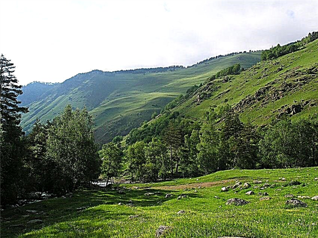
But even without them, there are enough significant waterways. Each river has its own purpose. The Moskva River stands out here as it combines recreational, transport and economic functions. You can also relax in Istra. Its reservoir and banks are built up with tourist centers. Fishing lovers visit Protva and Sturgeon, canoeists visit Yakhroma and Polya.
The longest rivers in the Moscow region
The largest rivers of the Moscow region - a list, photos with names and descriptions.
Oka
River of the European part of the country. One of the largest tributaries of the Volga. Towns on the river: Stupino, Kolomna, Serpukhov. An important navigable artery of the region. There are many historical sights not far from the coast, such as the 19th century buildings in the city of Kashira. The Prioksko-Terrasny Nature Reserve was founded in the Serpukhov District.
The length of the river is 1,500 km, in the Moscow region - 176 km.
Klyazma
Refers not only to the Moscow region and Moscow, but also to three other constituent entities of the Russian Federation. Khimki, Korolev, Noginsk are on the river. There are environmental problems upstream. In the summer, Klyazma attracts kayakers. On the left bank, not far from Kovrov, a state nature reserve was founded. It flows into the Klyazminskoe reservoir. A modern health complex has been built on its banks.
The total length of the river is 686 km.

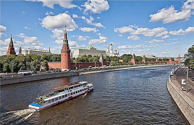
Moscow river
Mostly flows in the capital and the Moscow region. The Moscow basin includes 362 rivers. Large settlements: Zvenigorod, Mozhaisk, Kolomna. The river is navigable from the Rublevskaya dam for 210 km towards the mouth. Navigation lasts from mid-spring to late autumn. There are several beaches in the northern part of the capital. The construction of the canals was the reason for the formation of the islands.
The total length of the river is 502 km.

Protva
It flows in the Moscow and Kaluga regions. It originates near the village of Mokrino, flows into the Oka. One of the largest cities on the coast is Vereya. The bottom is embossed, there are rifts and holes, so the depth in adjacent areas can vary significantly. In the upper reaches the Protva is overgrown with reeds, a lot of snags. There is good fishing on the river, mainly perches, podleschik, pike.
The total length of the river is 282 km.
Sturgeon
Refers to the territory of the Moscow, Tula and Ryazan regions. It flows into the Oka above Kolomna. Coastal settlements: Zaraysk and Serebryanye Prudy. The channel is located in a picturesque valley, there are limestone outcrops. Crossed by the federal highway "Don". The ichthyofauna is diverse, but sturgeon species have stopped coming here for spawning due to the construction of dams and hydroelectric power plants.
The total length of the river is 228 km.

Dubna (tributary of the Volga)
It flows in three areas. It flows into the Uglich reservoir. The largest city on the coast is Dubna. The active use of the river for economic purposes has led to water pollution. Several tourist routes have been developed, including both hiking along the coast and rafting. Fishing is convenient both from boats and land.
The length of the river is 167 km, in the Moscow region - 137 km.

Nara
Located in the Moscow region and the Kaluga region. The translation of the name is “stream”. It flows out of the Poletskoye Lake, flows into the Oka. Naro-Fominsk and Serpukhov are on the river. In the upper reaches, there is a fish processing plant of the same name, which has ponds. Dam ruins can be found in the middle and lower reaches. The water in the river is classified as “dirty” in terms of quality class.
The total length of the river is 158 km.

Ruza
Located in the west of the region. The source is near the village of Maloye Krutoye and flows into Moscow. In the past, a hydroelectric power station operated on the river, but it lost its significance and was shut down. The water from the adjacent reservoir was drained, and the sluices were dismantled. At the same time, there are two operating reservoirs - Verkhneruzskoe and Ruzskoe. The main attraction of the right bank is the Nezhdinskoye settlement.
The length of the river is 145 km.

Llama
It flows in the Moscow and Tver regions. One of the most likely translations of the name is "long narrow valley". Although the water quality class is “dirty”, the ichthyofauna is represented by more than 10 species of fish. The most ancient city of the Moscow region, Volokolamsk, was founded on the river. The Zavidovsky nature reserve was founded nearby. Sightseeing - the estates of the Chernyshevs, Zagryazhsky and Goncharovs.
The total length of the river is 139 km.

Sister (tributary of Dubna)
Mostly flows in the north of the Moscow region. The source is the Klinsko-Dmitrovskaya ridge, flows into Dubna. On the river is the city of Klin. It belongs to the plain type, has a winding channel. The Senezh reservoir was built on the Sestra. The largest tributary is Yakhroma. The most active fishing is in the lower and middle reaches. Here the water is cleaner and there are great depths.
The length of the river is 138 km.

Pakhra
The river of the capital and the Moscow region. The source is the swamps of the Naro-Fominsk region, flows into Moscow. The translation variant of the name is “flowing from the lake”. One of the major cities on the coast is Podolsk. The most significant tributaries: Mocha, Rozhayka, Desna. Several dams have been built along the entire channel. In winter, it is fed by springs. In recent years, fish have been killed due to pollution.
The length of the river is 135 km.

Istra
River of the north and central part of the Moscow region. It starts near Pokrovka and flows into Moscow. The reservoir of the same name is based on the river. The area is picturesque, recreational tourism is developed. More than 50 recreation centers have been built, including Barefoot, Lepota, Impulse. The main attraction is the Resurrection New Jerusalem Monastery.
The length of the river is 113 km.

Vorya (tributary of the Klyazma)
The source is located in the Dmitrovsky district, flows into the Klyazma. Before crossing Lake Ozeretskoye it looks like a narrow stream. In the warm season, you can meet kayakers on the river. The largest cities on the coast are Krasnoarmeysk and Khotkovo. There are recreation centers and sanatoriums, including "Monino". Sightseeing: Abramtsevo Estate Museum, Pirozhnaya Gora settlement, Nikolo-Berlyukovskaya Pustyn.
The length of the river is 108 km.

Lopasnya
It flows in Moscow and three districts of the Moscow region. It flows out of a small lake near the village of Epiphany and flows into the Oka. It has 36 tributaries over 10 km long. To control the spill, several dams have been built near settlements or within their boundaries. The riverbed is winding, with dense vegetation along the banks. Sightseeing: the village of Talezh, founded in the Middle Ages, and many buildings in the city of Chekhov.
The length of the river is 108 km.

Tsna (tributary of the Oka)
The source is located east of the village of Shuvoe, flows into the Oka. In the upper reaches, dams were built, due to which ponds and the Shalakhovskoye reservoir were formed. The main settlements are located downstream. There are hiking trails along the river bed. There are sections of the river where you can kayak. Fishermen come here for roach, pike, pike perch.
The length of the river is 100 km.

Severka (a tributary of the Moskva River)
Refers to the southern territories of the region. The source is the village of Stepygino, which flows into Moscow. There are rifts in the channel. They were formed due to the construction of the dam. The coastal zone is partially overgrown with reeds. The lower reaches have the least amount of forests. Excavations were carried out on the coast and human remains were found, which are from 3 to 5 thousand years old.
The length of the river is 98 km.

Nerskaya
It is located in the Orekhovo-Zuevsky and Voskresensky districts of the region. Refers to the number of left tributaries of Moscow. It flows through artificial and natural lakes.Since the shores are sandy, the access to them is convenient. There are places for tents. Mushroom pickers, fishing and hiking enthusiasts come here. High water kayaking is also popular.
The length of the river is 92 km.

Fields
It flows within the urban district of Yegoryevsk and the Shatursky district. Formed near the village of Korobyata. It is a left tributary of the Klyazma. During floods, they can be rafted along the riverbed by kayaks and inflatable boats. On the coast or not far from it there are: a giant pine on the left bank, Lake Smerdyachye, a holy spring and an abandoned bell tower near the village of Shatur.
The length of the river is 92 km.
Forehead
Refers not only to the Moscow region, but also to the Tver region. It originates near the village of Shakhovskaya, at Bolshiye Gorki it flows into Shoshu. Along the river bed, landscapes are constantly changing: dense thickets, bare banks, pine forests, swampy areas. It has 4 large tributaries. In the middle reaches, good fishing season. Pike bite best of all. There are good areas for rafting.
The total length of the river is 91 km.

Desna (tributary of the Pakhra)
Formed at the confluence of Pakhorka and Butynya near Kalininets, it flows into Pakhra near the village of Dubrovitsy. The name has a Slavic origin from the word "right hand" and translates as "right hand". The water at the bottom is colder than in neighboring rivers because of the gushing springs. The largest settlements are Troitsk and Aprelevka. There are several rather large tributaries, for example, Dunno.
The length of the river is 88 km.

Iskona
It flows in the west of the Moscow region. It is a left tributary of Moscow. In the past, it was of strategic importance for the region. The disappeared city of the same name stood on it. Now only villages and dacha settlements remained on the coast. Tourists prefer the middle course. There are scenic hiking spots as well as the best fishing opportunities from the high banks.
The length of the river is 77 km.

Kashirka (tributary of the Oka)
Belongs to the urban district Domodedovo and the Stupinsky district. It flows out of a small lake near the village of Glotaevo and flows into the Oka. The banks are high, covered with forest. There are several tributaries, for example, the left Sitnya and the right Bunchikha. In summer, there is a strong shallowing. But during floods, the river is widespread and attracts lovers of water tourism.
The length of the river is 68 km.

Velia
It is located in the Sergiev Posad and Dmitrievsky districts of the Moscow region. The source - near the village of Ivashkino, flows into Dubna. There are several small settlements along the coast, including Palchino and Frolovo. In the middle course there are moraine hills and canyons. In the lower channel, the channel is straightened. The ichthyofauna is diverse, fishermen can be found at any time of the year.
The length of the river is 62 km.

Urine
It originates near Machikhino, flows into the Pakhra. It features rocky shores, there are limestone outcrops. It has more than 10 fairly large tributaries. There is a hunting farm. Fishing depends on the season. The best pecks are dace, small roach, minnows. Although in shallow waters the fish is visible to the naked eye, those who like to sit with a fishing rod come here only on occasion.
The length of the river is 58 km.

Yakhroma
Refers to the Pushkin and Dmitrovsky districts of the region. It used to be longer, but the construction of the Moscow Canal led to a cut in the channel. It is a tributary of the Sister. The upper course is interesting for hikers, the lower one - for kayakers. The Yakhroma reservoir was formed on the river. This is a fishing place where roach, pike and perch are found. Fishing is prohibited in the spawning grounds.
The length of the river is 54 km.

Big Sister
It flows in the west of the region. It originates in a swampy area of the forest near Shablykino. It flows into the Lamu River near Borodino. In the upper reaches in 1996, a nature reserve of regional significance was founded. Here you can find rare fish species, including European grayling, which is found only in clean water bodies. Sightseeing: Iosifo-Volotskiy Monastery and Teryaeva Grove.
The length of the river is 55 km.

Hotch
On the territory of the Moscow region there is 44 km of its channel out of 55 km of total length. The rest belongs to the Tver region. It is a right tributary of the Volga. In the lower reaches there are mixed and coniferous forests, as well as fewer swamps than the upper and middle. 10 km of the river, starting from the mouth, are navigable. At the same time, there are some difficulties and limitations with navigation. The best fishing spots are near the estuary.
The total length of the river is 55 km

Kolomenka
The source of the river is the Stupinsky district, and the mouth is Kolomna. In urban areas, the dam does not allow the reservoir to overflow during floods. There are forest belts on the coast only in the upper and middle reaches. Places with great depths are chosen for fishing. Roach, perch and pike bite especially well in the area of the mouth. Sightseeing: Kolomna Kremlin and Speed Skating Center.
The length of the river is 51 km.

Horn
Located in the south of the Moscow region. Refers to the tributaries of the Pakhra. There are dams along the entire channel. During the flood period, which falls on the second half of spring, it attracts kayakers. Remarkable objects of architecture, nature and history have been preserved on the banks. For example, the Vorobyovo estate, Nikitsky caves, Bityagovskaya kurgan group. The city of Domodedovo is located on the Rozhaika.
The length of the river is 51 km.

Yauza
It flows not only in the region, but also directly in the capital. Within the city of Moscow - 27.6 km. It is a tributary of the Moskva River, and the mouth is located at the Bolshoi Ustinsky Bridge. In the past, the role of the Yauza in shipping was more significant, but even now it is partially available for small vessels. Sightseeing: Andronikov Monastery, Lefortovo Palace and the Church of St. Sergius of Radonezh.
The total length of the river is 48 km